Posts tagged maps
image  Colonial Dress, detail
Colonial Dress, detail

"Colonial Dress (detail)," by Susan Stockwell , 2009 :: via WHATTHECOOL
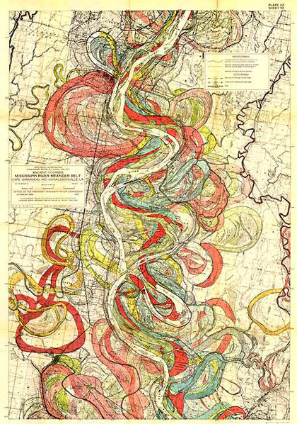
"Mississippi River Meander Belt: Cape Giradeau, MO–Donaldsonville, LA," from Geological Investigation of the Alluvial Valley of the Lower Mississippi River, by Harold N. Fisk, 1944 :: via Pruned, Boing Boing
This bit of virtuoso cartography overlays the meanders and jumps taken by the lower Mississippi River over the past few thousand years. The time-compression inherent in geography always boggles the mind. I love how it looks like a mix between an abstract expressionist painting and an intestinal diagram.
Nate: 

from "The Unintended Consequences of Cul-de-sacs," by Ania Wieckowski, Harvard Business Review, May 2010 :: via The Infrasructuralist
These maps compare the possible routes of a one-kilometer walk in two neighborhoods in the Seattle area: the heavily cul-de-sac'd Woodinville and the gridded Ballard neighborhood. Cul-de-sacs (or, if we're sticklers for French grammar in our loan-words, culs-de-sac, or if we're actual French, les impasses) are designed, in part, to free residential suburbs from the noises and hazards of automobiles, with the side effect of making it nearly impossible to go anywhere without a car. I suppose a secondary effect of the culs was to mask the depersonalizing qualities of vast suburbs of near-identical houses all built over the course of a few months—again, at the depersonalizing cost of making coming and going by foot, bicycle, or public transit much more difficult. In an added layer of irony, the map on the right looks far more organic, almost lung-like, but (our shifting urban values tell us) the mathematical abstraction on the right is the one more suited to healthy city life.
Nate:
image Have story, will travel
Have story, will travel
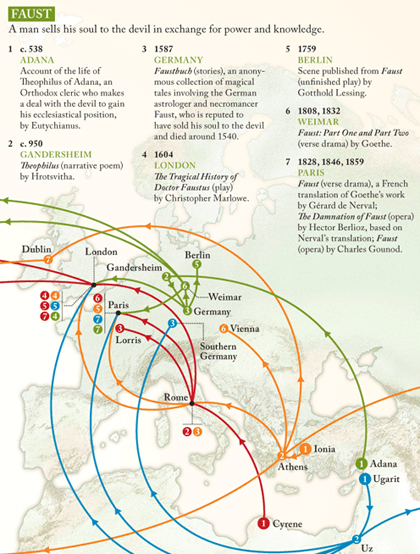
from "Telling Tales: The evolution of four stories," by Haisam Hussein, Lapham's Quarterly, Spring 2010 :: via Strange Maps
I like the idea behind this map—which charts the evolution of four near-archetypal literary tales (Faust, Leviathan, Oedipus, Pygmalion) across space and time. It reminds me of the wonderful encyclopedias that academic folklorists compile of recurring motifs in folktales, myths and legends. The end result suffers, alas, from too few data-points and too many lines: the flight-tracks imply a causality and certainty of a single route that isn't always the case from story to story.
Nate:

from New World Order," featuring map art by Shannon Rankin, BLDGBLOG, 31 March 2010
Artist Sannon Rankin makes intriguing collages and assemblies out of cut-up maps. I love the beauty of the concept, and am ever-enthralled by the idea of reconfiguring our cartographies—our ideas of what the world is like, where things belong, how things connect.
Nate:

from "Tacoshed," by students of the California College of the Arts, with David Fletcher and Rebar, 2009–2010 :: via BLDG Blog
An attempt to map the journey taken by all the ingredients of a taco sold at a local taco truck in San Francisco. You can view a larger, barely legible version of this fascinating chart here. The orange lines on the map are thickest for edible shipments, thinner/dotted for aluminum and propane. The bar graph at the lower left lists the ingredients and distance travelled; the bar thickness indicates the type of shipment—thickest for trucking, thinner for train travel and ocean voyages. The list of ingredients, from least- to most-travelled is: Salt, Cheese, Tomatoes, Californian Propane, Cilantro, Sour Cream, Onions, Beef, Corn Oil, Lime, Tortillas, Pinto Beans, Chicken, Avocados, Rice, Saudi Arabian Propane, Adobo Seasoning, and Aluminum.
Nate:


from Life:Size Book # 001, by Roland Tiangco, 2009 :: via Book Cover Archive
Here's something pleasing from a young Brooklyn artist: "Book # 001 of a series of books which contain 100% printed reproductions of everything in our world." With a big nod in the direction of Jorge Luis Borges, who imagined an ancient empire where the craft of cartography had become so exact that the entire realm was mapped on a 1:1 scale, which of course covered the entire realm. "In the western Deserts, tattered Fragments of the Map are still to be found, Sheltering an occasional Beast or beggar; in the whole Nation, no other relic is left of the Discipline of Geography." Tiangco's first 1:1 reproduction is of an anthropology bookshelf; the whole thing is printed single-sided and perforated, so you can cut up the book and make a giant, bookshelf-sized poster out of it. Hey, it's probably cheaper than Books by the Foot.
Nate:

from "Where The Buffalo Roamed," Weather Sealed, 22 September 2009 :: via information aesthetics
One of the marvelous things about the Internet: if you have ever had an idle thought ("I wonder how far away you can get from a McDonald's location in the continental United States?") someone else has obsessively, thoroughly researched and answered it. The map shows every McDonald's location in the lower 48 states. The answer to the idle question: 145 miles.
Andy:

from Strange Maps, 6 June 2009

from "Predominant shape of roof based on ethnographic boundaries and Human Area Relations Files data," AfricaMap :: via Google Maps Mania
AfricaMap is an effort by several Harvard University departments to make geographical data about the continent easier for researchers access and use. They've got lots of modern and historical cartography, with overlay maps showing all sorts of topographic and cultural features. This screenshot shows regional architectural styles, using data from George Murdock's 1959 book Africa: Its Peoples and their Culture History. As with any color-coded map, this is probably better at showing general trends than it is at ruling things out in a given region. Still, it is a little odd that there are three different color codes for "unknown."
Nate
:
Book photo, from On the Map, by Stefanie Posavec, hi-res images at NOTCOT, 2 April 2008 :: via FFFFOUND!
Stefanie Posavec has created a beautiful series of pattern-maps based on the text of Jack Kerouac's On the Road, tree and slice and squiggle diagrams showing sentence-length and theme. This is, presumably, the text she worked from, which shows its own beauty of careful reading.
Nate
:
repost  The new old cartography
The new old cartography
A nice review of some of the notable maps of the just-completed year, with a little bit of map history (carefully omitting much, as any good map should) as an intro.
Nate
:Geography | How the new cartography is like mapmaking in the Middle Ages: Today’s maps are “geographically accurate beyond the dreams of a medieval mind,” yet they’re still, perhaps more than ever, vehicles for representing the world’s geography as the mapmaker idiosyncratically interprets it — never mind getting from point A to point B. [Boston Globe]

"Electronic Superhighway: Continental U.S.," by Nam June Paik, Smithsonian Museum of American Art, photo by angela n (Flickr), 8 October 2007 :: via Intelligent Travel
I like how the Mississippi River seems to glow extra-brightly, a nod perhaps to a superhighway of a different era.
Nate
:
Tundra quilt, 20 by 23 inches, by Leah Evans Textiles :: via Design Boom
Part of a lovely series of map-based quilts of estuaries, geological structures, and agricultural installations. I love the way it adds softness and dimensionality to the flattened landscape. Reminds me, too, of the Gerard Manley Hopkins' pied-beautiful description of "landscape plotted and pieced / fold, fallow, and plough"
Nate
:
video  Arrivals and departures
Arrivals and departures
from "airtraffic," by Karl Rege et al., The Zurich School for Applied Sciences:: via Autopia
Every commercial airline flight in the world, over a twenty-four hour period—a visual reminder of the scale and scope of culture, and the unprecedented ways that air travel connects us to one another. Also a reminder that prosperity and connectivity go together, and their distribution is uneven, to say the least.
Andy
:
image They vote by night
They vote by night
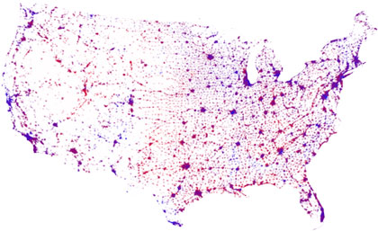
Composite image by Nate Barksdale from NOAA and UM sources linked below, 9 November 2008
Among all the fascinating maps that've been made of the US voting patterns for the 2008 presidential election, I couldn't find the one I really wanted to see: a map showing both voter percentages and population density on an undistorted projection. With fancy databases it wouldn't be hard to do, but I did come up with a way to Photoshop an approximation, combining the red-blue-purple county-percentage map from the University of Michigan with the famous satellite image of nighttime illumination. It's not a total match for population—gas flares get counted as voters, for instance—but it comes closer than anything I'd found.
Nate
:
image Geography of longing
Geography of longing

"Missed Connections: Where, Exactly," by very small array, 14 July, 2008.
Here's an alternative to the state-by-state maps we're being bombarded with in these latter electoral days: "Of the latest fifty craigslist missed connections posts per state, as beginning on midnight of the most recent Sunday, not including spam, responses or miscategorized posts."
Nate
:
from "Globes," a segment on the Discovery Channel's How It's Made :: via kottke.org
OK, so it's not exactly what Peter Berger had in mind when he said "All human society is an enterprise of world-building," but could I resist the charms of this video of the inside of a cardboard-globe factory? I could not. (A video about the manufacture of the clay globe that is the Culture Making logo would, presumably, be a bit simpler.)
Nate
:
repost The trouble with online maps
The trouble with online maps
I think the Cartographic Society's argument only carries so far—first, because any map-making is by its nature an act of editing, simplification, stylization, and erasure; and second, because as the technology improves, we'll start to see more ways of accessing the info included on the old maps as well as the new.
Nate
:The president of the British Cartographic Society says Internet mapping (Google Maps etc.) is wiping away the richness of Britain’s geography and history. She says “corporate cartographers” are leaving off landmarks like churches, ancient woodlands and stately homes. And history out of sight is history out of memory. [BBC]

Northern Lights Blvd, Anchorage, Alaska, Google Street View
The Google Street View car in Alaska seems to have had its camera rained on—but it does make for a nice abstract picture of a rather ordinary retail boulevard in Anchorage (just up the street from an aging strip-mall called the Valhalla Center).
Nate
: